Rock, Rampart, Riddle: A Weekend with the Borders' Oldest Landmarks
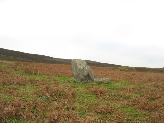
Photo: Eric Jones, CC BY-SA 2.0, via Wikimedia Commons
The Borders are usually sold on the medieval: abbeys in ruins, peel towers, battle sites. Fair enough. But climb the Eildons on a clear morning and you are walking over something far older than any of that, on ground that was enclosed, built on and probably argued over two thousand years before the first monk arrived.
This is a weekend for the prehistoric Borders. Not because it is showy — it is mostly grass, stone and a bit of a ditch — but because the quietness of these places is the point. You will often have them to yourself. Bring boots, a map, low expectations and a bit of imagination.
First, a Word About What We Don't Know
Archaeologists describe these sites with a confidence that the evidence doesn't always support. 'Ritual' is a useful word that usually means 'we're not sure'. A stone circle might be a calendar, a gathering place, a burial monument, a boundary marker, or several of those at different times. Cup-and-ring marks — those spirals and concentric circles pecked into rock — have been studied for a century and a half and nobody can tell you what they mean.
That is not a reason to skip them. It's the reason to look properly.
Day One: The Eildons
Three summits above Melrose, and a walk that earns its views. Eildon Hill North carries one of the largest hillforts in Scotland: ramparts enclosing a broad summit scattered with the platforms of several hundred roundhouses. There were Bronze Age cairns up here too, and later a Roman signal station, which tells you something about how useful a hill with a view of everything has always been.
The climb from Melrose is short and steep. Go early, take the obvious paths rather than cutting across the earthworks, and give yourself time on the top. The fort is best read by walking its perimeter and looking out — you can see why here, and you can see why somebody else wanted it.
Day Two: Edin's Hall and the Whiteadder
North, into the Lammermuir fringe, for Edin's Hall Broch near Abbey St Bathans. A broch this far south is unusual, and this one sits inside a wider Iron Age settlement of roundhouses and enclosure walls, on a slope above a burn. There's a waymarked walk in from a small car park on the minor road; it's rough underfoot and muddy for much of the year.
Pair it with a wander along the Whiteadder and you have a full, satisfying day. The broch itself is a low, thick-walled ruin rather than a tower — don't arrive expecting Mousa — but standing inside the wall line with the hillside falling away below is a good place to think about how much of this landscape was once somebody's farmyard.
Day Three: The Cheviot Edge
South-east of Morebattle, the ground rises towards the Cheviots and the sites get steadily more serious. Hownam Rings is a multi-phase hillfort excavated in the 1940s, whose sequence of ditches and ramparts helped shape how archaeologists think about Iron Age settlement in southern Scotland. A short way on, Woden Law sits above Dere Street, with Roman practice works cut into the slopes nearby — soldiers rehearsing a siege on a hillfort that may well have been occupied at the time.
This is a proper hill day: tussocky grass, no waymarks to speak of, and weather that changes its mind. Take a paper map and know how to use it. If you only do one thing, walk up Woden Law and look down the line of the Roman road.
Reading Cup-and-Ring Marks
Scattered across the Tweed and Teviot valleys are outcrop panels and portable stones carved with pecked circles, sometimes with a groove running out from the centre. They are small, easily missed, often on private farmland, and best researched in advance rather than hunted for on the day. Canmore (Historic Environment Scotland's online record) and the local historic environment record will give you grid references and access notes.
When you find one: look, photograph without flash, and leave it alone. Skin oils and repeated handling dull the carving. Chalk outlines and paper rubbings — once standard practice — do measurable harm and are rightly discouraged. Don't move loose stones. Don't metal-detect: it is illegal on scheduled monuments, and any archaeological find in Scotland, of any age, should be reported to Treasure Trove.
Practical Notes
Parking at all of these is small and informal; never block a field gate. Expect livestock. Keep dogs close and under control around sheep, and on a short lead near anything with young. Bracken is chest-high by July and hides ankle-breaking holes; late autumn and early spring are the kindest months for these walks. Daylight is short from November to February, so plan for a 4pm finish rather than a 5pm one.
And check before you go: some of these sites sit on working farms, and access can change with the season or the tenant. A polite ask at the farmhouse is rarely refused.
Visiting Without Leaving a Mark
The Borders' prehistoric sites have survived because nobody made them into attractions. That is also their vulnerability. Don't light fires on cairns, don't build your own, don't climb on standing stones for a photograph, and don't fly a drone over a scheduled monument without consent.
What you can do is slower and better: sit with a site for twenty minutes, work out where the ground falls away, where the entrances are, what the builders could see. You won't solve the riddle. You'll come away with a much older sense of the place than the one the guidebooks give you.