The Land Speaks: A Map-Reader's Guide to Borders Place Names
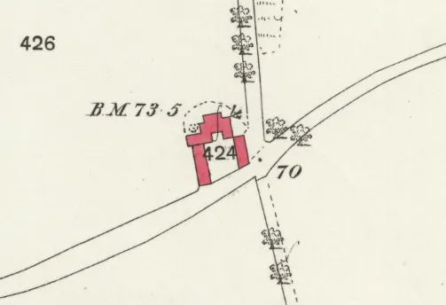
Photo: Ordnance Survey, Public domain, via Wikimedia Commons
A 1:25,000 map of the Scottish Borders is one of the most entertaining documents you can buy for eight pounds. Read it as a list of words rather than a set of lines and it starts telling you things the guidebooks skip: which fields flood, which hills were flattened for a reason, where cattle went in June, and where the water was engineered long before anyone thought to write it down.
This is not a scholarly exercise. You do not need Old English to enjoy it. You just need to know that most Borders names are descriptions, and that a handful of elements keep turning up. Learn six words and half the map opens.
Four languages in one parish
Borders naming comes in layers, like everything else here. The oldest is Brittonic, the P-Celtic spoken before the Angles arrived — a cousin of Welsh, sometimes called Cumbric. On top of that comes Old English, brought up from Northumbria from the seventh century onwards, which gives us the workhorse words: hill, field, farm, church. Scots arrives in the medieval period with its own vocabulary for upland grazing and river engineering. And there is a Gaelic layer in the uplands and along the old routes from the west, which is why names like Innerleithen and Glenholm sit only a few miles from thoroughly English ones.
Nobody tidied this up. The result is a palimpsest, and the fun is in spotting which layer you are standing on.
The four you will meet first
Haugh
A haugh is flat riverside meadow — the ground that floods, and the ground that grows the best grass because of it. It comes from Old English halh, meaning a nook or a patch of dry ground in a wet place. You will find haughs attached to farms all along the Tweed and the Teviot, and Blackhaugh on the A72 outside Clovenfords is a good, easy example to look at on a drive. Stand there and notice the land is flat, low and close to the water. The name is a flood warning that has been in place for a thousand years.
Law
A law is a rounded hill — Old English hlaw, originally a mound or burial hill. In practice, a 'law' on a Borders map usually means a hill that stands out and has something on top of it. Rubers Law, the conical hill above Denholm, is the textbook case: a hillfort crown, a big view and a name that tells you people were up there long before you. Ward Law, which appears in several places, adds another element — ward, a watch — and suggests somebody was looking out.
Shiel
A shiel is a summer pasture hut, the temporary dwelling shepherds and cattle herders used when the herd went up to the high ground. The word comes into Scots from Old Norse skjól, shelter. Once you know it, Galashiels reads differently: usually explained as the shielings by the Gala Water, it is a name about seasonal grazing, not town planning. Cauldshiels Loch near Melrose carries the same element. Look for shiel names on the higher ground and in the side valleys, and you are looking at the old summer economy of the uplands.
Cauld
Here is one with two meanings, which is half the pleasure. Cauld can be simply 'cold', from Old English cald. But on Borders rivers it usually means a weir — the low built barriers that hold water back for mills and fishing. The weirs on the Tweed near Yair and Fairnilee are caulds in that second sense, and Cauldshiels Loch might lean either way depending on who you ask. Nobody is certain, and that is fine. Uncertainty is part of the deal.
Gorges, hollows and wet ground
Cleuch (also spelled cleugh) is a steep-sided ravine, from Old English clōh. Look at the Cheviot fringe on a map and you will find them in their dozens, black and white and nameless — the kind of feature you would never notice from the road and would remember for years if you walked up one.
Hope is a small enclosed valley, usually a side valley running up into the hills, from Old English hop. Riskinhope and Chapelhope at the head of St Mary's Loch are good examples, and a map of the Cheviot edge is essentially a list of hopes.
Slack is a shallow dip or hollow, from Old Norse slakki — a reminder that Norse words travelled widely in Scots even where the Norse never settled. Moss is peat bog, and any farm name containing it is telling you the ground there is soft. Sike is a small ditch or trickle of a stream, the kind of thing that decides whether your boots stay dry.
Ridges, knolls and other bumps
Rig means a ridge, from Old English hrycg, and it doubles as the word for a raised strip of ploughland. That is why rig and furrow is the term for the corrugated earth you see in old pasture — a whole field of long, low ridges, each one a 'rig'.
Knowe is a knoll, a small rounded hillock. Dod is a rounded, bare-topped hill — Scots, blunt and descriptive. Drum is a ridge in Gaelic, druim, which is why Drumelzier in the Tweed valley below Broughton is worth a glance at the map before you drive through it. Side simply means hillside, and turns up attached to a descriptor in names like Whiteside and Hartside. Craig is a crag, from Gaelic creag.
The Gaelic and Brittonic layers
Innerleithen is the easiest Gaelic lesson in the region: inbhir, meaning a river mouth or confluence, plus the Leithen Water. Glenholm, near Broughton, pairs Gaelic gleann with the Scots 'holm'. Peebles may come from a Brittonic word for tents or shelters. Melrose is recorded by Bede as Mailros, Old English for bare or bareish moor. Selkirk is often explained as 'church by the shieling', Hawick as a hedged farm, Jedburgh as the burgh on the Jed, and Kelso's older name Calcow as a chalk hill-spur.
And then there are the rivers. Tweed, Teviot, Ettrick, Yarrow — these are old, opaque names, and anyone who tells you with total confidence what they mean is overselling it. Treat them as the oldest layer of all, laid down before any of the languages above.
A day out to read the land
This works as one long day, or split across two. Bring the OS Landranger 73 and 74 sheets, or the Explorer equivalents, and read them in the car park before each stop.
Start at Peebles, then follow the Tweed east to Innerleithen for a confluence, and on to Drumelzier for a ridge and Glenholm near Broughton for a glen. Cross to St Mary's Loch and look at the hopes running up the hillsides at the head of the water — a flat half-hour along the loch shore is enough to see the shape of them.
Drop down the Yarrow to Selkirk, then Galashiels for the shiels, and out to Clovenfords where Blackhaugh gives you a haugh at eye level. Melrose pairs an abbey with Cauldshiels Loch a short drive away, and then it is over to Denholm for the best finish in the region: a walk up Rubers Law, roughly two hours there and back at an easy pace, past rigs and cleuchs on the map and up onto a hillfort with the whole of Teviotdale laid out below.
The free interpretive layer
None of this requires an expert. It requires a map, a pair of boots and the willingness to say a name out loud and look at the ground it belongs to. Once you can read the words, you cannot unsee them — and every drive through the Borders starts coming with subtitles.