The Wall That Went Before the Map: Reading the Drystane Dykes of the Lammermuirs
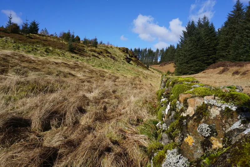
It is very easy to walk past a drystane dyke. Most of us do it for hours at a time in the Lammermuirs, using them as handrails, windbreaks and somewhere to shelter from a squall, and never once looking at how they are actually put together. Which is a pity, because a Borders dyke is one of the few bits of landscape you can read like a document. Every gap has a reason. Every bulge has a history. Every patch of brighter, newer stone tells you roughly when somebody cared enough to fix it.
So this is a half-day route built around that idea. It starts and finishes at Longformacus, a small village strung along the Dye Water at the foot of the Lammermuirs, and it treats the walls as the thing worth looking at rather than something to scramble over on the way to a summit. There is no great height gained and no scrambling. What there is, instead, is about five miles of quiet field edge, moor road and hill track, with a few hundred years of enclosure, sheep and estate boundary work laid out on either side of you.
The route, roughly
Start in Longformacus itself — there is limited parking near the kirk, so arrive early and park as though the village has to live there after you have gone. Head west out of the village on the track that shadows the Dye Water, then pick up the right of way that climbs north-west onto the open hill. This is the only real pull of the day, and it is short: something in the region of 150 metres of ascent, spread over a mile and a bit.
Once you are up on the moor edge, the walk becomes a long, loose loop. Follow the track as it swings north and then east, keeping the big march dyke on your right as a guide, before dropping back down into the village on the returning track. Allow two and a half to three hours at an easy pace, plus whatever time you lose standing about looking at stones. Take OS Explorer 345 (Lammermuir Hills) or Landranger 67. Waymarking is patchy, the ground is soft in places after rain, and the hill is exposed — this is not a route to attempt in low cloud without a map you can actually use.
Learning to read a wall in ten minutes
Almost everything you need to know about a dyke is visible from the outside, if you know what you are looking at.
Start with the batter. A well-built wall leans in slightly on both faces, tapering towards the top. That is not decorative; it is structural. A wall with vertical faces is a wall that is already thinking about falling over.
The coverband — the row of larger stones laid on edge along the top — is the bit that does the weatherproofing. Where it has gone missing, you will usually find the core of the wall eroding out underneath it, like a jacket with the shoulders worn through.
Throughstones are the long ones that run right through the width of the wall, tying the two faces together. On older dykes they sit about a third of the way up and you can often spot them as a line of flatter, wider stones breaking the pattern of the coursing.
Look, too, for smoots — small square openings left at the base, traditionally to let water off the hill and, depending on who you ask, to let rabbits and hares pass without having to climb. A dyke without them is either very new or has been rebuilt by someone working from a photograph.
And then there is the stone itself. Down here you get a mix: greywacke and whinstone, some sandstone, and in the older stretches whatever the field had lying around in it. The patchwork is the giveaway. A run of tidy, flat-bedded stone against a run of rough rubble usually means two different jobs, possibly a century apart.
What the waller said
Halfway round, on the high ground, I fell into conversation with a waller called Alec who has been dyking in these hills on and off for the best part of forty years. He was repairing a short stretch where the coverband had collapsed, working alone with a bucket of small hearting stones and a hammer, and he was happy enough to talk while he worked.
The thing he wanted me to understand was that a dyke is not really a barrier. “You're no' building a wall,” he said. “You're building a drain that happens to be vertical.” A properly built double dyke has a core of small stones — hearting — packed between the two faces, and that core is what sheds water and stops the whole thing turning into a sponge. Get the hearting wrong and the frost will have the wall apart inside five winters.
He was less sentimental than I was expecting about gaps. A hole in a dyke, to a walker, looks like neglect. To Alec it looked like a job, or sometimes like a decision: a place where a beast was pulled out, a place where a drain needed clearing, a place where the estate stopped bothering in 1963 and nobody has bothered since. “There's dykes up here that'll never be right again,” he said, cheerfully. “That's no' a tragedy. That's just the hill.”
If you want to see the craft done properly rather than patched, keep an eye out for local dyking demonstrations and competitions at the Borders agricultural shows in late summer, and for the work days run by walling groups and estate volunteers. It is worth watching once. The speed of a good waller is genuinely startling.
Why they still matter
It would be easy to file all this under nostalgia, but the dykes are doing real work. They shelter stock, they slow run-off, they give shelter to everything from wrens to lichens, and they mark boundaries that predate almost every fence on the same line. Where a dyke has been replaced by wire, you can usually still see the old footings running underneath — the new boundary walking the same route as the old one, like a road built on a Roman road.
They also give the walk its shape. Without the walls, this would be a pleasant but formless circuit of moor edge. With them, you have a route with punctuation: a corner to stop at, a stell (sheep pen) to peer into, a march dyke to follow when the path goes vague.
Practical bits
- Distance: roughly 5 miles, 2.5–3 hours, one short climb.
- Footwear: boots. The moor section holds water.
- Weather: assume wind. There is very little shelter above the village.
- Gates: leave them as you find them. This is working farmland, and the sheep are not curious about your route.
- Walls: look, photograph, do not climb and absolutely do not pull stones out to make a gap. A dyke is somebody's boundary and, more often than you would think, somebody's unpaid weekend.
- Dogs: fine on the open hill, leads on anywhere near livestock.
Getting there without a car is genuinely awkward. The nearest stations are Dunbar and Berwick-upon-Tweed, both a taxi ride away, and the bus service to Longformacus is thin. Realistically this is a drive-and-park walk — so share the car, take your litter home, and leave space for the folk who actually live at the end of the track.
Afterwards, Duns or Lauder will sort you out for a late lunch, and there is something quietly satisfying about eating a sandwich while the dyke you have just spent three hours admiring sits outside doing its job, unbothered, exactly as it has for two hundred years.